

Climate Change/Sea Level Rise Commission BayLand Presentation at Community Input Session on March 16, 2023
Anna Johnson, Project Engineer with BayLand Consultants & Designers, Inc., held a community input session with a power point presentation on “San Domingo Creek and West Side Stormwater and Harbor Infrastructure Assessment and Flood Mitigation Study”. BayLand is interested in your feedback regarding flooding concerns, areas of peak interest, and any mitigation solutions you would like to see implemented. Please complete the survey and return it to Anna Johnson, PE at ajohnson [at] baylandinc.com (ajohnson[at]baylandinc[dot]com).
San Domingo Creek and Westside Stormwater and Flood Mitigation Study – Vulnerability Assessment Presentation on May 11, 2023
The Town received a briefing on the San Domingo Creek and Westside Stormwater and Flood Mitigation Study from BayLand consultant and Project Engineer, Anna Johnson. She reviewed with the CC/SLRC and public their vulnerability assessment for the at-risk flooding areas on the San Domingo Creek side of St. Michaels. Ms. Johnson will use this information and feedback to move forward with this project and plan to meet again with the Town and public on August 10, 2023 at the 5:00pm meeting.
San Domingo Creek and Westside Stormwater and Flood Mitigation Study – Mitigation Strategies Discussion on August 10, 2023
Anna Johnson, BayLand consultant and Project Engineer, presented BayLand’s draft mitigation strategies for the San Domingo Creek side of St. Michaels at risk flooding areas to the CC/SLRC and the Town residents. The CC/SLRC will use this updated information to make decisions toward designating which of BayLand’s Conceptual Design will be carried out to 30% Construction Design Plans. Ms. Johnson’s Progress draft of this project. Please note that this is a DRAFT and will continue to be modified as the project progresses to completion. More detailed explanation
San Domingo Creek and Westside Stormwater and Flood Mitigation Study – Draft Report and 30% Design Options Reviewed on November 9, 2023
BayLand’s Anna Johnson, presented their latest draft report and two option designs for the proposed Back Creek Park living shoreline on the San Domingo Creek side of St. Michaels to the CC/SLRC. They have chose option two to carry forward to 30% Construction Design Plans. Please note that this is a DRAFT and will continue to be modified as the project progresses to completion. Two Design Options of the St. Michaels San Domingo Creek and West Side Stormwater and Harbor Infrastructure Assessment and Flood Mitigation Study. More detailed explanation
San Domingo Creek and Westside Stormwater and Flood Mitigation Study – Final Draft Report and 30% Design Option Presented to the Commissioners on December 13, 2023
BayLand’s coastal engineer and project manager, Anna Johnson, presented their final draft report and 30% design option proposed for Back Creek Park living shoreline on the San Domingo Creek side of St. Michaels to the Commissioners of St. Michaels, CC/SLRC, and our community. Final Draft Powerpoint Presentation, Final Report, and 30% Design Option. More detailed explanation

St. Michaels Floodwatch
The Climate/Change/Sea Level Rise Commission is pleased to present St. Michaels Floodwatch, an interactive tool to help residents and visitors to our town understand the effect that sea level rise and nuisance flooding will have over the next 30 years. On the Floodwatch site, you can view projections of what chronic nuisance flooding is projected to look like by 2050, overlaid on satellite images of the town and throughout Talbot County. You can also view photographs of recent flooding events in critical areas around town.
Residents are also invited to submit their own images of local flooding through the Maryland MyCoast app.
Andrew Thaler, from the Climate Change/Sea Level Rise Commission, and Kate Vogel, from Maryland DNR, will present both the Floodwatch project and MyCoast app during a Lunch and Learn session at the St. Michaels Library at 11a.m. on January 19, 2023.

GMB Community Input Session Open House for West Harbor Road/East Chew Avenue Sea Level Rise and Stormwater Flooding Conceptual Design on March 30, 2023
Brent Jett, P.E., CFM, CC-P, Sr. Project Manager/Coastal Resiliency Group Leader (and author of the initial Harbor and Stormwater Infrastructure Study) along with other Architects/Engineers with George, Miles & Buhr, LLC (GMB), held an open house on “Resiliency Through Restoration: West Harbor Road/East Chew Avenue Flood Mitigation Feasibility Assessment and Conceptual Design” to allow the community to ask questions and provide crucial community input, while taking time to better understand this study. Aerial view depicting the area of interest for this study. GMB is interested in your feedback regarding flooding concerns, areas of peak interest, and any mitigation solutions you would like to see implemented. Please visit this link, complete the attached survey and return it to Brent Jett, PE at bjett [at] gmbnet.com (bjett[at]gmbnet[dot]com).
GMB Community Input/Feedback Session for West Harbor Road/East Chew Avenue Flood Mitigation Study was held on July 13, 2023
GMB developed two design concepts for the West Harbor Road/East Chew Avenue area which they shared with the community and received their feedback toward moving forward with this project. Below we have attached several documents related to this project for your review. Please join us at our next meeting on August 15th when GMB will share the findings of their stormwater evaluation and more discussions will be held regarding proposed options.
Brent Jett’s Power Point Presentation
West Harbor Boat Slip Parking Memo by Mr. Glackin
West Harbor Parking Survey Results by Mr. Glackin
July 13, 2023 CC/SLRC Minutes Summary by Mr. Glackin
GMB Presentation for West Harbor Road/East Chew Avenue Flood Mitigation Study to the Commissioners of St. Michaels, CC/SLRC, and Community at the COSM Working and Legislative Session held on December 5, 2023
GMB presented their Resiliency Through Restoration: West Harbor Road/East Chew Avenue Flood Mitigation Feasibility Assessment and Conceptual Design Final Report to the Commissioners for their approval.
Brent Jett’s Power Point Presentation
Advanced Assistance Grant Flood Mitigation Study from FEMA, administered by MDEM, Town of St. Michaels, MD – Cherry Street/Honeymoon Bridge-Harbor Walkway Presentation on January 26, 2024
The Town of St. Michaels and the Climate Change/Sea Level Rise Commission (CC/SLRC) have received an Advanced Assistance grant form the Federal Emergency Management Agency (FEMA), administered by the Maryland Department of Emergency Management (MDEM), to address the sea level rise and stormwater flooding projected in our Town’s future. The first phase of this study is to develop an overall concept plan for the Cherry St./Honeymoon Bridge-Harbor Walkway, Burns St., and Mill St. Area. The Town has hired Rauch Inc. to assist in completing this study. Their study will develop an overall concept plan for this area in the first half of this year. Then building on this concept plan, Rauch will complete the detailed design and construction drawings in the second half of the year.
On January 25th, 2024, Rauch Inc. and Annapolis Landscape Architects made an initial presentation to brief the residents of Cherry Street/Honeymoon Bridge-Harbor Walkway on the study, receive their input and allow them to participate from inception of this project.
On January 31st, 2024, Rauch Inc. and Annapolis Landscape Architects met with the Chesapeake Bay Maritime Museum to provide them with an initial presentation and obtain their input from inception of this project.

St. Michaels Awarded Harbor Flooding & Stormwater Mitigation Project Grant
The Town of St. Michaels has been awarded another large grant to tackle the threat of Rising Sea Level and Stormwater Flooding. Working with the Maryland Department of Emergency Management, the Climate Change/Sea Level Rise Commission has secured this $210,000 federal grant. The Federal Emergency Management Agency recently approved the grant money for the St. Michaels Harbor Flooding & Stormwater Mitigation Project.
This Project is to develop a concept plan and gather Benefit Cost Analysis (BCA) information to address flooding concerns at Cherry St./Honeymoon Bridge – Harbor Walkway, Mill St., Burns St., Muskrat Park/Church St., and Mulberry St. This grant will complete the development of Concept Designs for the critical flooding areas of our main harbor identified in our initial Harbor and Stormwater Infrastructure Study.
The CC/SLRC is preparing for the Kickoff meeting for this grant and is looking forward to beginning implementation of this grant in the second half of this year. This project will be done in two phases spread out over the next three years. The first phase will focus on the Cherry St./Honeymoon Bridge-Walkway, Mill St., and Burns St. area. The second phase will focus on Muskrat Park/Church St. and on Mulberry St. areas.
The CC/SLRC are looking forward to working with our St. Michaels Community as this project proceeds and the concept plans are developed.
On January 25th, 2024, Rauch Inc. and Annapolis Landscape Architects made an initial presentation to brief the residents of Cherry Street/Honeymoon Bridge-Harbor Walkway on the study, receive their input and allow them to participate from inception of this project. Please view the meeting presentation by clicking HERE.
On January 31st, 2024, Rauch Inc. and Annapolis Landscape Architects met with the Chesapeake Bay Maritime Museum to provide them with an initial presentation and obtain their input from inception of this project. Please view the meeting presentation by clicking HERE.
On June 13th, 2024, Rauch Inc. and Annapolis Landscape Architects presented the following Draft Concept Plans to the CC/SLRC and public. Please view the Power Point Presentation by clicking HERE. To view the Concept Drawings only click HERE.

Advanced Assistance Grant Flood Mitigation Study from FEMA, administered by MDEM, Town of St. Michaels, MD - Cherry Street/Honeymoon Bridge-Harbor Walkway Presentation on January 26, 2024
The Town of St. Michaels and the Climate Change/Sea Level Rise Commission (CC/SLRC) have received an Advanced Assistance grant from the Federal Emergency Management Agency (FEMA), administered by the Maryland Department of Emergency Management (MDEM), to address the sea level rise and stormwater flooding projected in our Town's future. The first phase of this study is to develop an overall concept plan for the Cherry St./Honeymoon Bridge-Harbor Walkway, Burns St., and Mill St. Area. The Town has hired Rauch Inc. to assist in completing this study. Their study will develop an overall concept plan for this area in the first half of this year. Then building on this concept plan, Rauch will complete the detailed design and construction drawings in the second half of the year.
On January 25th, 2024, Rauch Inc. and Annapolis Landscape Architects made an initial presentation to brief the residents of Cherry Street/Honeymoon Bridge-Harbor Walkway on the study, receive their input and allow them to participate from inception of this project. Please view the meeting presentation by clicking HERE.
On January 31st, 2024, Rauch Inc. and Annapolis Landscape Architects met with the Chesapeake Bay Maritime Museum to provide them with an initial presentation and obtain their input from inception of this project. Please view the meeting presentation by clicking HERE.
On June 13th, 2024, Rauch Inc. and Annapolis Landscape Architects presented the following Draft Concept Plans to the CC/SLRC and public. Please view the Power Point Presentation by clicking HERE. To view the Concept Drawings only click HERE.

Envision the Choptank Technical Assistance Obtained for Two Areas in St. Michaels
St. Michaels has received assistance from the Center for Watershed Protection, Inc. (CWP) to assist the Town with two stormwater/drainage projects. They include the Chester Park & North Street Area Drainage and the DNR San Domingo Creek - Back Creek Park Living Shoreline, Tide Gate Study. As part of the collaborative efforts, Envision the Choptank will assist the Town with funding opportunities and applications, grants, and project management, to list a few.
On May 28th, 2024, a North Street to Chester Park Lane Stormwater Project Community Meeting was held and the attached slide show presentation was shared by Envision the Choptank. Click HERE to view the presentation slides.
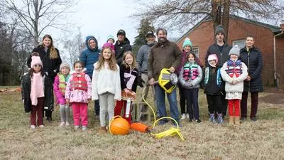
Smart Buoy Deployed on December 15, 2024
Andrew Thaler, PhD, a deep-sea ecologist, member of the Climate Change/Sea Level Rise Commission (CC/SLRC), and owner and CEO of Blackbeard Biologic Science and Environmental Advisors has developed a plan to implement a “Smart Buoy” which will monitor and report the exact water levels in the St. Michaels Harbor. As quoted by WBOC’s Lauren Miller: “It will measure the combined weight of water and atmospheric pressure on top of it,” he said. “We’ll take that measurement, combine it with the barometric pressure—so we’ll take away the atmospheric pressure—and then we can use that to measure how high the water level is.”
On Sunday, December 15, 2024, Dr. Thaler accompanied by St. Michaels Girl Scout Troop 799, deployed the Smart buoy in the lagoon between Honeymoon Bridge and Mill Street. Dr. Thaler provided educational instruction on the purpose, mechanism of monitoring and data which will be extrapolated from the buoy to aid the St. Michaels community in their endeavors to mitigate storm surge, sea level rise and nuisance flooding issues around the harbor. The girl scouts, in efforts to earn their Citizen Scientist and Climate Champion badges, participated in an interactive learning session by performing hand refractometry water salinity readings, a question & answer session with Dr. Thaler, and an opportunity to create a personal time capsule placed into the cavity of the buoy which will be opened after a year of data collection. One of the highlights of the afternoon was the opportunity to name the buoy… “Crabby Claws," conceived by the Girl Scouts during this event.
For the next year, the yellow buoy with the solar panels, is the smart system and satellite link, will remain in the lagoon between Honeymoon Bridge and Mill Street recording tidal data for this research project. This real-time data will be beneficial in making accurate assessments to help St. Michaels be more resilient to these more frequently occurring flooding and normal high tide events. Thaler commented in his interview: “We’re going to see those flooding events more and more frequently,” he said. “We really want to know how many times a year we expect to see those happening, and we can use that to project how many times we would expect to see them in 2030, 2040, or 2050.” The Town is hoping to be able to share this data on their website to allow the community to engage in this project.
We thank Dr. Thaler, Girl Scout Troop 799, and their parents for their time and dedication toward steering St. Michaels’ Sea level rise mitigation future! Our future looks bright with these prospective “scientists” already navigating the posterity toward preserving St. Michaels’ coastal beauty!
WBOC’s Lauren Miller was on the scene to document this momentous occasion. You may view this excerpt at https://www.wboc.com/news/smart-buoy-to-help-st-michaels-monitor-rising-sea-levels/article_1f157c70-bb46-11ef-927a-ebc29f5e611f.html.
While the deployment was a success and the buoy logged tidal height throughout the month, the buoy is currently out of the water for maintenance following the recent hard freeze and will be back in Honeymoon Lagoon early in the New Year.